
 Asset Publisher
Fire protection
 Samolot podczas gaszenia pożaru
 Oznakowanie dojazdu pożariowego Nadleśnictwo Krzystkowice
 Pasy typu D biologicznego zabezpieczenia
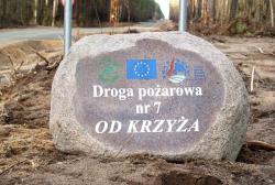 Przykład oznakowania dojazdu pożarowego (fot. M. Kołodyński)
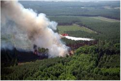
 Pożar lasu wykryty z samolotu
Organization of forest fire protection in The Regional Directorate of State Forests in Zielona Góra.
- All Forest Divisions of RDLP in Zielona Góra are classified to I (highest) category of forest fire risk (serious risk).
- Zielona Góra County Forests belong to the most combustible in the whole Poland.
- It results from dominant existence of natural boracic habitat (56 %) and pine trees as (almost 90 %) and superiority of forest stands of younger age class (average age of forest stand is 52 years old).

OCHRONA PRZECIWPOŻAROWA – RDLP Zielona Góra
1. Observation system
The net of observation posts constitutes noticeably classical observation towers occupied by
observers.
Within the area of RDLP, there are 65 items altogether, including:
- distinguishably metal – 61 items
- visibly made of bricks/concrete – 3 items
- camera mast of closed-circuit TV – 1 item
(plus 3 items of TVs working at certain moments in Ranger's Alert and Disposition Post (Polish abbreviation PAD) of Forest Divisions)
Brick Fire Observation and Lookout Tower
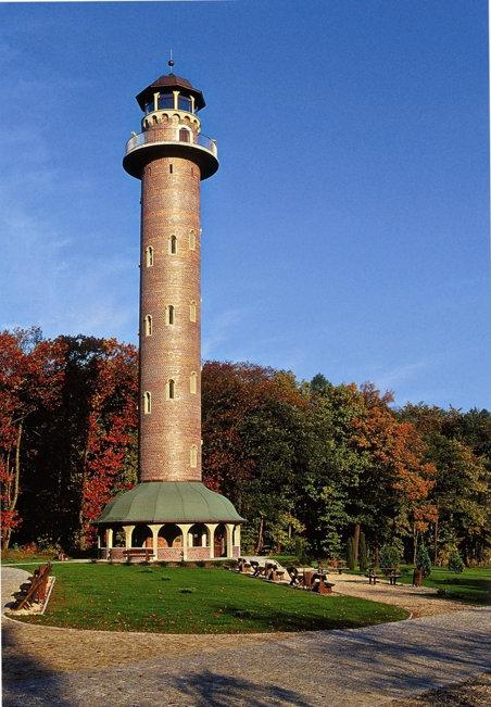
- fire protection and education of nature and forest
- it is located within Promotional Forest Complex (Polish abbreviation LKP) of Lubusz Forest (Polish name Bory Lubuskie) – built and financed under the Phare programme, National Fund for Environmental Protection and Water Management (Polish abbreviation NFOŚiGW) and State Forests
2. Monitoring & detection
METEOROLOGICAL FORECASTING AND WARNING (METEOROLOGICAL MEASURING STATIONS)
8 automatic weather stations, including:
- 2 weather forecast stations
- 6 supporting measuring stations
The scale of the fire hazard (Polish abbreviationSZPL)
Defining the scale of forest fire hazard in prognostic zones:
- measurement of plant litter humidity (Fresh Forest – Polish abbreviation Bśw) and relative humidity of air at a height of 0,5 meters over the sea level at 9.00 a.m. and 1.00 p.m.
- establishing scale of the fire hazardin the morning and afternoon hours of certain day
- announcing scale of the fire hazard for Forest Divisions and State Fire Service


The risk of fire
Forecasting the fire hazard for local needs (for Forest Divisions)
Concerning the computer program (The Risk of Fire), measurement of meteo factors at 8.00 a.m. and forecasting meteorological conditions (weather forecast) there are statedthe following:
- forecast of the fire hazard for the further part of the day
- forecast for the morning of the next day
- recommended actions for Forest Divisions and State Fire Service
- forecast of possibility of forest fire development (simulation) after 15, 30 oraz 45 minutes of free spread of fire
Communication System of Ranger's Alert and Disposition Post
Communication of Ranger's Alert and Disposition Post of Forest Divisions
- radio communications with neighbouring Forest Divisions and Regional PAD on the basis of two-way radios with stationery base, car and portable radiotelephones working at frequency channel dedicated for State Forests
- network of mobile phones and stationary Local Forest Service
- radio and phone communication with Directing Positions of District (+ Internet)
Communication System of Regional Ranger's Alert and Disposition Post RDLP in Zielona Góra includes:
- radio, phone and web communication with subordinated Forest Divisions and neighbouring RPAD
- communication with Directing Position of Voivodeship (Polish abbreviation WSK) and Directing Position of District (Polish abbreviation PSK)
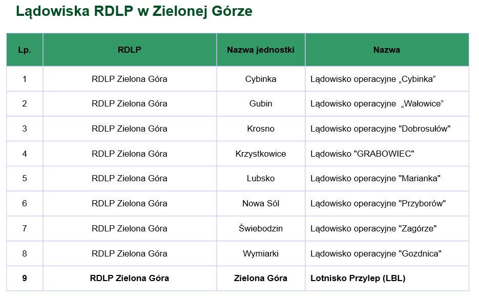
- communication with Forest Air Base – disposal of chartered airplanes (airplanes patrolling and extinguishing fire of forests )
- radio communication with Department of Lubusz Province Governor's Office
3. Informtion & map projection
Information data set about the area for fire protection purposes
- basic range of Electronic Maps (Polish abbreviation LMN) resources
- expanded range in connection with additional information concerning important elements of fire protection (address and operating data necessary to conduct firefighting and Occupational Safety and Health (Polish abbreviation BHP) activities)
- a map – an access card towards the fire of forest
- a map concerning current situation for firefighting action and fighting section purposes
The internet map server of eLAS – fire alarm module
- application available in all PADs of Forest Divisions and in RDLP
- fire protection map called Localize Fire – setting the place of the fire
- automatic generation of access maps to the fire place (disposable and operational) on the basis of:
- coordinates from Fire Towers
- current geographic coordinates
-indicated address of forest fire
- pointing the direction of fire development on the map on the basis of current direction and strength of the wind
- information about fires, which occurred in given period of time – certain years (reports)
4. Modeling & simulation
- warning and analysis of current weather conditions
- fire weather– air temperature > 24oC, air relative humidity < 40%, humidity of forest litter <12%, lack of precipitation, no cloudiness or partial cloudiness
- simulation of fire development after its appearance on the basis of factual conditions for Forest Divisions Needs and for Country Fire and Rescue System
- computer program called Fire Forest Model

5. Management of fire action
The attorney of superintendent of forests– basic duties:
- organising and carrying out rescue and fire action until the arrival of the Firefighters
- cooperation with Rescue Disaster Coordinator (Polish abbreviation KDR) responsible for the whole action
- coordination and disposition of people and means of The State Forests National Forest Holding (Polish abbreviation PGL LP)
6. Registering & processing
There are registered all events – fires and interventions for the following purposes:
- prevention
- cost analysis
- evaluation of system organisation and functioning
- data base in order to create reports
7. Air patrolling and extinguishing a forest fire
Charter Airplanes – Flying Club of Lubusz Land in Przylep:
Fire airplanes AN-2R:
- range: 1390 km
- capacity of main fuel tank: 1700 litres
- + 60 litres for foam extinguishing agents
- optimal speed at the air drop : 160 km/h
- air cruising speed : 180 – 200 km/h
- plane crew – 2 people (pilot + mechanic)
Patrol Plane Zlin-142:
- air cruising speed: 180 – 200 km/h
- optimal speed over the fire circle: 140 – 160 km/h
- plane crew: min. 1 person
- optimal time of patrolling: up to 4,5 h
State of starting capability for fire aircrafts according to Operating Instructions of forest fire protection [among others].
Time from taking the airplane into disposition to the plane take-off according to the Degree of Forest Fire Danger (Polish abbreviation SZPL):
- 1 SZPL – 15 minutes
- 2 SZPL – 10 minutes
- 3 SZPL – 5 minutes
Fire access roads (in km) for RLDP Zielona Góra:
- out of the management board of LP – 2 050,35
- in the management board of LP – 2 864,28
- total : 4 914,63
Water supply stations (items) for RDLP Zielona Góra:
- natural – 360
- man-made – 310
- fire-hydrants – 132
- total: 802
Fire breaks (km) for RLDP Zielona Góra:
- A – 1 259,42
- B – 70,89
- BK – 384,57
- C – 42,61
- D – 332,61
- total: 2 090,10
Chosen project concerning fire protection performed in the RDLP area in Zielona Góra in 2013.
- Pilot implementation within good practice and cooperation (program European Forest Fires Monitoring Using Information System (EFFMIS) with participation of The Forest Research Institute) of chosen Spanish solutions concerning fire protection (EMERCARTO and NOMO projects).
- Pilot implementation of application edited by The Forest Research Institute at the request of the General Directorate of State Forests „Fire Forest Model" (simulation of forest fire development).
- Project continuation of forest and public Road cross-linking within the whole RDLP in Zielona Góra (navigation in case of forest fire).
- Cross-border cooperation with Faculties of Forestry of Eastern Saxony in Germany concerning fire prevention and fight against fires of forests.
Proposal of cooperation with Germans (Eastern Saxony) in the area of fire protection of forest for year 2013
- Exchange of information – defining ways of passing current information on the existence of fires in cross-border zone and range of necessary data related to forest fire protection (including maps of fire protection).
- Analysis of framework for performance of joint venture in tactical and operational exercises with participation of Forest Fire Protection Services and The Fire Fighters from the both countries. The whole undertaking is to be realised in year 2014 in the cross-border forest complex.
- Joint educational informational projects referring to prevention of fires (including bilingual informational and promotional materials).
Paweł Wcisło

